|
|||||||||||||||||||
 |
 |
||||||||||||||||||||||||
Beaches Waiheke Island is famous for its high saturation of scenic beaches, having a huge presence all over the island. (follow the below guide by viewing them on Google Maps) Among them are: Oneroa Beach - The main beach on Waiheke Island, located along the northern side of the town Oneroa. Little Oneroa Beach - A small, secluded beach at the east end of Oneroa Beach, separated by a protruding cliff wall. Palm Beach - Similar in shape to Oneroa Beach (complete with protruding cliff wall on the east end, that separates a small, private beach), it gets its name from the mature phoenix palms at the east end. Little Palm Beach - A small beach at the west end of Palm Beach, famed among nudists. Blackpool Beach - The south-facing counterpart of Oneroa Beach, lining Blackpool, popular for kayaking and windsurfing. Surfdale Beach - A zoned-in beach on the southern side of Surfdale, separated from Blackpool Beach by a small, protruding peninsula. Also popular for kitesurfing. Onetangi Beach - A 1.87km long, north-facing beach lining Onetangi. For many years it has been the site of the Onetangi Beach Races. Its western (and often inaccessible end at high tide). Cactus Bay - Considered by many Waihekeans as the island's most perfect beach, and with nearby Garden Cove, a romantic place for picnicking. The beach is accessible only by boat or kayak, as its land access was blocked off by a private landowner. |
|||||||||||||||||||||||||
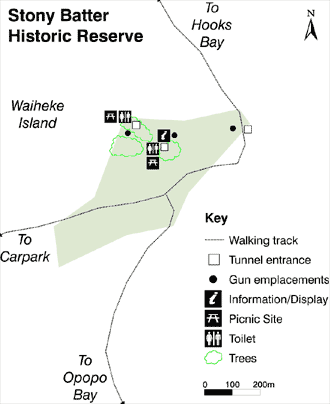
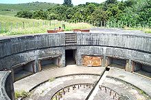
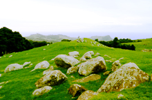
Waiheke Island is in the Hauraki Gulf of New Zealand 17.7km (about 35 minutes by ferry) from Auckland. Of the Hauraki Gulf islands, it is the second-largest (after Great Barrier Island), the most populated and the most accessible by regular ferry and air services. Waiheke is the third most populated island in New Zealand, after the North and South Islands. Waiheke Island has a permanent population of around 8,000 residents. Much of the population lives close to the western end of Waiheke Island, at or close to an east-west isthmus between Huruhi Bay and Oneroa Bay which, at its narrowest, is only 600 metres wide. Download a PDF of infomation to take with you Island Stats History of Waiheke Island Discovered and settled by Maori approximately 1000 years ago, Waiheke translates to "cascading waters". Some Maori legends relate that one of the pioneering waka (canoes) to New Zealand came upon the island. The first traces of Europeans arrived with the missionary Samuel Marsden in the early 1800s, several years after Captain Cook passed by and acknowledged the island in his travels through the Hauraki Gulf. Places of InterestSigns of Maori occupation on Waiheke Island still exist today. Archeological sites are scattered over the island including more than forty pa sites, cooking pits and terraced areas. Stony Batter Historic Reserve and Defence Complex
|
|||||||||||||||||||||||||
 |
|||||||||||||||||||||||||
Home I Rates I Booking I Contact I Features of the house I Useful Information I Photos I About Waiheke I Things to do I Wine & Food I Maps I Pets OK |
|||||||||||||||||||||||||